July 16, 2011
Where might drilling happen?
I didn't manage to get to it, but the the Tompkins County Council of Governments Task Force on Gas Drilling presented "Looking Down From Above: What Gas Drilling Sites Might Look Like in the Town of Dryden" on Tuesday. Fortunately, the slides are available, so I'll be basing a few entries on the slides.
All of this looks at how gas drilling might happen, if in the end, it's allowed. The public hearing for the proposed Dryden ban is this Wednesday, July 20th, at 7:00pm at the Dryden Town Hall.
The presentation started with an introduction to gas drilling, discussion of Pennsylvania experience, and a general discussion of the maximum number of possible drilling pads spaced evenly across the landscape. Dryden could have 93 drill pads (of 8-12 wells each at 640 acre spacing) on that model - but that only establishes a maximum unlikely to be reached. The more likely reality for Dryden, based on leases, the way they cluster, and New York State's compulsory integration laws, is more like 44.
(That's assuming the lease map is correct - it may have changed since it was created or have other imperfections.)
I'll tell the story a little differently, focusing on their forecasts of where drilling pads might go and the impacts on the area. The key maps I suspect Dryden readers will want to see are on pages 24 and 26 of their part B, which I've pulled out as DrydenN.pdf (270KB PDF) and DrydenS.pdf (274KB PDF).
For folks on the edges of the town, I've also broken out Caroline (North) (393KB PDF), Groton (385KB PDF), Lansing (North) (426KB PDF), and Lansing (South) (426KB PDF).
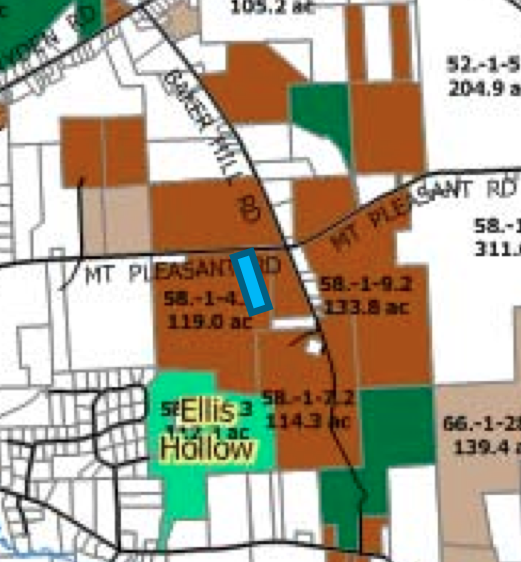
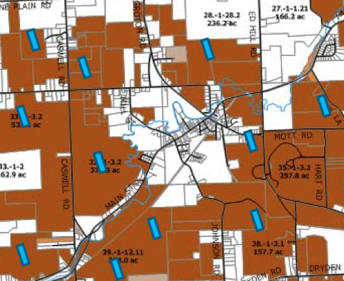
I'm going to focus on two locations: one, selfishly, an isolated site on the hillside above my house, and the other a circle of sites around the Village of Freeville. I know the terrain and traffic patterns here, while the Freeville story can look at a network of sites around a small populated place.

Possible well pad on the hillside above my house. (Note that Baker Hill Road doesn't go through between Mount Pleasant and Eliis Hollow Creek roads.)

Possible well pads around the Village of Freeville.
Those markers aren't physically to scale - the impact of each well pad affects about 8.8 acres. However, I suspect that as the story emerges, those markers will feel too small. They also aren't placed precisely where drilling will take place. The gas companies will survey the landscape to decide where they want the pads, retention pads, wells, gathering lines, and the rest might go.
There'll be more over the next few days here.
Posted by simon at July 16, 2011 8:43 PM in energy , mapsNote on photos