August 27, 2011
Vacationing in a nodal development paradise
When we went to visit Angelika's family in Germany, I thought of it more as a vacation than as a land use planning study. Somehow, though, once you start looking at land use in one place, it's hard to stop looking at it everywhere. In Hamburg, at least, it was clearly urban land use and not very comparable to Dryden. When we visited her brother in Meissenheim, though, we were suddenly in a place with density similar overall to Dryden, but distributed extremely differently.
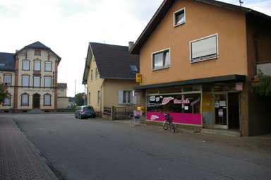
Meissenheim, more properly Meißenheim, is a village of 2338 people about 1 mile across near the Rhine River border with France. It has, despite very little through traffic, a small (recently added) grocery store, a bakery, convenience store, a guesthouse, parks and a big playground, a large natural area next door, its own schools, and substantial industry. Farming is important, with fields mostly of corn surrounding the village and tractors rumbling through it regularly. Horses and even pet deer are easy to find. (You can get a sense of it from a Google translation of the German wikipedia entry or by exploring the photo gallery.)
Like Dryden, it has two cities a short drive (or bus) away - Lahr, 43,000 people about 10 miles away, and Offenburg, 60,000 people about 12 miles away. (Strasbourg, 272,000 people, is only 21 miles away, but even though national borders matter much less now, is in France.)
Many businesses - the bakery, guesthouse, cafe, convenience store, and grocery - are roughly where the railroad used to be, before it went away in 1959. (The grocery store is the only one with a substantial parking lot, and it's a recent addition on the very edge of the village.)
While much of the town is residential, of course, it's also a place of extremely mixed uses. Barns and farmhouses are in the village, not out in the fields, and there is certainly industry next to residential, as these signs ("Attention, children playing, 20mph", and "Trucks, unload to the left") suggest.
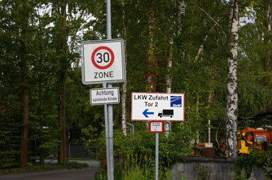
Children playing one way, trucks another.
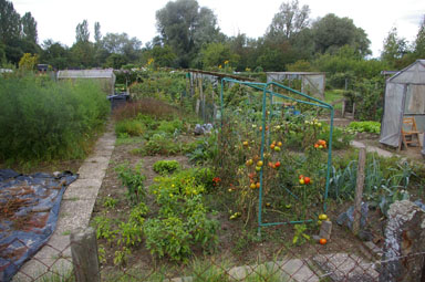
Many of the houses have gardens, as you'll see in the gallery, but not everyone has a garden or a large garden. A big community garden offers lots of space, easily reached by walking, for people who want more.
How is this possible? I've written before about the need for critical mass, and this many businesses shouldn't, by that logic, be supported by this small number of residents. Business here doesn't come from the road. 2338 just barely crosses the threshold where "population of about 2,000 to 2,500 is required to support the most basic neighborhood-scale commercial services." While the grocery store didn't seem to impress Germans much, I'd be delighted to have that on the corner here.
I could tell stories about Europeans being more community-minded and staying closer to home for their shopping, or describe gasoline prices that are substantially higher because of taxes, or invoke history and the need for defense along a historically dangerous border. In the end, though, I think it really comes down to the hard edges Germans have kept on their villages, from custom and through zoning.
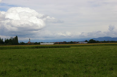
When you're between villages in this area, the main sign of civilization you can see is a church steeple against the sky. There aren't farmhouses, barns, or scattered houses. (I did see some sheds and greenhouses, as well as shelters for walking trails, and there were more isolated farmhouses in the Black Forest.)
The development pattern this produces is even clearer if you look at a map:
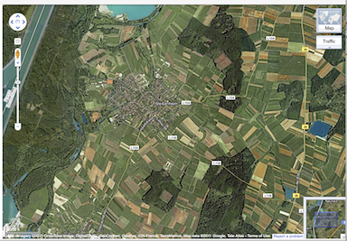
Concentrated village surrounded by uninhabited land (Click for Google Maps).
Meissenheim itself is very concentrated, with empty fields, forest, and water surrounding it. A few main roads - none particularly optimized for speed or volume - connect it with villages just off that map. None of those villages is that much larger than Meissenheim, and most have similar sets of services.
Under these conditions, smaller population numbers can support a larger number of businesses. I don't think, however, that this helps the argument for nodal development (or whatever the County would like to call it this year) in Tompkins County. Existing conditions don't look at all like this, and enforcing such behavior even on new development is simply not politically possible.
From Dryden's earliest settlement, isolated farmhouses have been common. A majority of residents live outside of the villages and hamlets. Even if gas prices climbed to German levels (or beyond), the amount of investment we've made in our existing infrastructure makes it unlikely that we'd suddenly shift into dense villages surrounded by genuinely uninhabited land.
If you'd like to get a better sense of this, I've posted a photo gallery of Meissenheim, photos of the southwestern corner of the village where we spent most of our time. As you'll see, it's not a medieval walled village (I'll post pictures of one of those later), but while it's modern and similar to Dryden in many ways, it feels extremely different from what we see here.
Posted by simon at August 27, 2011 6:49 AM in excursions , nodal development , planning and zoningNote on photos
