November 14, 2011
Dryden likely has several faults
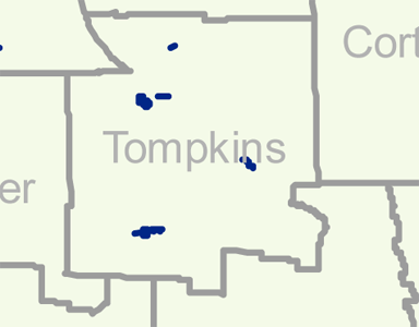
The last time I wrote about, this, I was pointing to what looked like a single small faulted area in Dryden along the Caroline town line.
That came from Figure 4.13 in the Geology section of the hydrofracking SGEIS (4.2 MB PDF). It, in turn, is based on a 1977 New York State Museum publication, which I guess I'll have to order.
However, Dryden Daily KAZ sent me a link to this article about many more probable faults:
Robert D. Jacobi, professor of geology and chair of the Northeastern section, contends that he and colleagues have uncovered increasingly convincing evidence that upstate New York is severely chopped by hundreds of faults of a kind characterized by very sporadic seismic activity...
But using a variety of field and satellite methods, Jacobi's group has found that there are hundreds of faults throughout the Appalachian Plateau, some of which may have been seismically active-albeit sporadically-since Precambrian times, about 1 billion years ago....
The researchers identified potential fault lines using remote sensing by satellite and low-flying planes. They then employed field methods, as well as magnetic fields and gravity measurements, to determine if those potential fault lines are indeed faults and if the faults extend down into Precambrian "basement," an indication that they could be seismically active.
We only have about 200 years of data, and there is little sign that these faults are active, so I'm not entirely surprised that the DEC didn't consider this more recent information critical to the seismic section of their report. Unfortunately, though, faults are also a key pathway for gases and sometimes liquids to move up through rock formations we normally think of as solid.
I tracked down Professor Jacobi's 2002 paper, Basement faults and seismicity in the Appalachian Basin of New York State and paid Elsevier $31.50 for it. It was worth that, and I'd encourage you to do the same (or track it down at Cornell) though it's pretty dense reading. You'll want to know what lineaments are in particular.
How did they figure out where faults were without digging through the entire area?
Evidence utilized for recognition of faults in NYS included the integration of FIDs [fracture intensification domains], E97 [EARTHSAT 1997 satellite] lineaments (Fig. 2), topographic lineaments, gradients in gravity and magnetic data (Figs. 3 and 4, respectively), seismic reflection profiles, and well logs. Integration of these data sets promoted the identification of numerous faults in the study area (Fig. 5). This paper illustrates the evidence for the confirmed faults, and demonstrates the characteristics and ubiquity of the faults for western, central, and eastern NYS (Sections 2, 3, and 4, respectively). Suspected faults, those that are not confirmed by outcrop structures, well logs or seismic reflection profiles, are discussed in Appendix A. (79)
The faults running through Dryden are "suspected" - the researchers did not confirm their existence here through surface features or seismic testing. However, the paper strongly suggests that this approach to finding faults works, with tests in other locations.
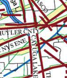
The maps created by their work yield a suspected fault map of Tompkins County and its surroundings like:

A more detailed look at suspected faults in Tompkins County. (fragment of Figure 5, page 86.)
That map shows two "X marks the spot" points of intersecting faults in Dryden. The smaller, more southern, one is along the Dryden-Caroline town line as before. The more northern one includes several different suspected faults - four or five, depending on how I count. The Tioga County fault runs north-south along what looks like Dryden's western edge, while the Schuyler County and Central New York State faults run east-northeast. The Owasco fault comes down from Auburn to about the Dryden-Groton line, where it intersects the Utica East fault (which is labeled near Utica on the map.)
Appendix A talks about those suspected faults, many of which are suspected because of both the 'lineaments' from satellite imagery and geological, mostly gravitational, anomalies. Some also run parallel to previously mapped faults. I'd encourage you to read pages 109 and 110 of the paper to find out more.
Don't run out and buy earthquake insurance. There's not much if any history of these faults being active, though (if they're really there) they've been around for millions of years and we only have around two centuries of records.
However, they make me think there's a lot more research worth doing before accepting the DEC's conclusions that we needn't worry about these issues with regard to gas drilling. More on that in my next piece about the SGEIS.
Posted by simon at November 14, 2011 9:13 PM in energy , geology , mapsNote on photos

I agree with the fact that there are many fault lines in New York and Pennsylvania. And that they link up together. What the DEC should realize that even with just a tremor the earth moves a few tenths of an inch. What's important to note is that when the tremor hits the point where the fracking water (that was forced down into the earth to help release the gas) a thing called liquification will happen. At that point the tremor could magnify and become many more tenths of an inch larger. I can fill my pool with a 5/8's hose in a few hours. Just imagine many of these liquification tremor cracks running the lenth of a fault line. That greatly increases the chances of the hydofracking liquids mixing with the good water we need.