February 7, 2012
Where's that fairway again?
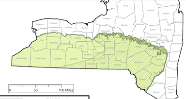
Now I'm starting to wonder if anything at all in the Geology chapter (4.2MB PDF) of the Revised Draft SGEIS on the Oil, Gas and Solution Mining Regulatory Program can be trusted. I posted a while ago about the 'fairway' it described, supposedly the best place to drill for gas. Dryden was inside the edge of that, as were Corning, where I grew up, and Auburn, where my mother grew up.

Marcellus Shale Fairway (darker
area with lines), Upstate New York.
The recent rant against Senator Seward from Energy In Depth Marcellus, however, shows a very different map.

A different take on the Marcellus Shale. (from EID Marcellus.)
EID Marcellus unfortunately doesn't give a source for its "economically viable" line here, but it's clearly calculated differently than the DEC's "fairway". In particular, it extends much further west, to the western edge of Cattaraugus County, includes much more of Allegany and Steuben counties, and much less of those troublesome Tompkins and Otsego counties.
It makes me start to wonder if gas companies are factoring local opposition into their economic calculations, or think it would cost less to operate in much more Republican municipalities. Given the number of other things that were geologically questionable in the dSGEIS, though, maybe the fairway map is botched too. Or maybe the shift toward drilling for oil and 'wetter' gas instead of the drier gas that's here may be having an impact.
I'll keep an eye and an ear out for explanations.
Posted by simon at February 7, 2012 7:08 AM in energy , geology , maps , politics (state)Note on photos
There's probably very substantial uncertainty on where it will or won't be economic given that they've actually done very little drilling in the area so far. Extrapolating from seismic etc is a pretty uncertain process.
Also, the price of natural gas lately won't be helping the economics.