February 21, 2004
Hamlet census
This week's sort-of Planning Board meeting on the Draft Comprehensive Plan's impact on Etna and Varna left me wondering about how many people actually live in the hamlets and what we data was available about them. In particular, the rental/owner-occupied question comes up regularly.
The census doesn't provide data for Etna or Varna because neither is incorporated - they're places, but they don't have government or well-defined boundaries. Because the Census Blocks map is available through CUGIR, I was able to get a map which broke the area down into reasonably fine-grained pieces, select appropriate pieces for each hamlet, and get totals for the selected area. (You need to have software to work with these maps, unfortunately. I'm using Manifold.)
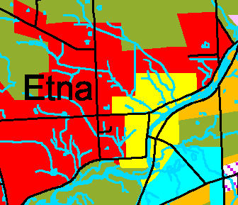
In Figure 5-1 of the Draft Comprehensive Plan (301 KB PDF), Etna looks like the picture below. The "hamlet" portion this calculation is about is just the yellow.

The hamlet area of Etna, as defined in yellow by the Draft Comprehensive Plan.
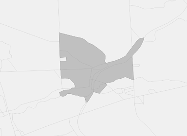
I took a stab at selecting census blocks which covered that area, as shown in the figure below. (You can click on it to see a larger version.)

Census blocks which include the hamlet of Etna as defined by the Draft Comprehensive Plan.
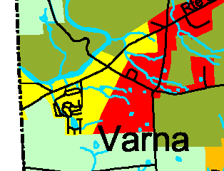
Then I did the same for Varna. This is Varna, in the Draft Comprehensive Plan:

The hamlet area of Varna, as defined in yellow by the Draft Comprehensive Plan.
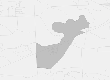
And this is Varna, as close as I can get in census blocks:

Census blocks which include the hamlet of Varna as defined by the Draft Comprehensive Plan.
Neither of these is perfect, but I think this is the closest possible approximation given the shapes of the blocks and the hamlets. The census block version of Varna includes a lot of empty Cornell-owned land, but that shouldn't affect the totals.
Given those areas, we get the population totals shown below:
| Population | Etna | Varna |
| Total | 379 | 679 |
| White | 358 | 568 |
| Black | 6 | 14 |
| Native American/Eskimo | 4 | 8 |
| Asian | 3 | 56 |
| Hawaiian/Pacific Islander | 0 | 1 |
| Other | 2 | 7 |
| Multi-racial | 6 | 25 |
| Hispanic | 7 | 19 |
| Males | 175 | 306 |
| Females | 204 | 373 |
| Under 5 | 36 | 36 |
| 5 to 17 | 62 | 61 |
| 18 to 21 | 17 | 39 |
| 22 to 29 | 47 | 173 |
| 30 to 39 | 76 | 128 |
| 40 to 49 | 47 | 85 |
| 50 to 64 | 63 | 85 |
| 65 and up | 31 | 72 |
Moving to households, we get:
| Households | Etna | Varna |
| Total Households | 162 | 368 |
| Household - 1 Male Only | 21 | 62 |
| Household - 1 Female Only | 26 | 111 |
| Married, Children | 30 | 37 |
| Married, No Children | 40 | 61 |
| Male Head of House, Child | 5 | 1 |
| Female Head of House, Child | 13 | 21 |
| Families | 96 | 130 |
And looking at housing, we get:
| Housing Units | Etna | Varna |
| Total Housing Units | 172 | 385 |
| Vacant | 10 | 17 |
| Owner-Occupied | 122 | 174 |
| Renter-Occupied | 40 | 194 |
One issue worth pointing out here is that it's not entirely clear how the census accounts for mobile homes which are owned by their occupants but which are in a park with fees. So far as I can tell, these are counted as owner-occupied, not as rentals.
The next step will involve figuring out density, which will mean working with a different map to calculate acreage of the properties in these hamlets without Cornell's experimental fields or the Plantations.
Posted by simonstl at February 21, 2004 03:54 PMNote on photos