April 20, 2004
Planning board on subdivision, hamlets, agriculture
Thursday night's Planning Board meeting included a sketch conference for a proposed sudivision on Sheldon and Wood roads near Etna (map) as well as continued discussion of the Draft Comprehensive Plan's sections on hamlets and agriculture.
The Planning Board welcomed new member Jim Crawford, and approved the minutes from the previous meeting, the first minutes to appear on the town's web site in a long time.
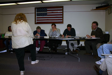
The next discussion, which lasted about an hour, concerned the Daniel Armitage subdivision, which Joan Portzline presented. The initial sketch is oriented with north to the right. Sheldon Road's curve is the northern edge of the property in question. Wood Road runs along its eastern edge, and the road on the left edge is Etna Road. Parcels labeled with letters are part of Phase I, and the parcels listed with acreage are part of Phase II, except the lots in the northwest and the one with a a house shown on it, which have already been sold.

Joan Portzline explains details of the Daniel Armitage subdivision to the Planning Board.
The area used to be Cornell research fields, and all of the parcels in Phase I have access to electricity along Sheldon Road. There was discussion of stormwater management - apparently there had been a presentation on stormwater that afternoon - though the lot already includes drainage put in earlier.
Most of the other questions the Planning Board had related to issues of how responsibilities fall if the property is subdivided and sold to people who develop individual lots as opposed to subdividing and developing it simultaneously, as well as to issues around adding driveways to these lots. Planning Board member Tom Hatfield noted that the line of properties in Phase II would be adding six road cuts in a quarter mile, which would be really dense, and was also concerned about the eight potential driveways into Sheldon Road. There were questions about whether shared driveways were possible; Board member Joseph LaQuatra pointed out a lawsuit in progress against the town over a shared driveway on Bone Plain Road. There were general questions about the use of flag lots - narrow driveways to large parcels.
Deed restrictions also came up a number of times, as Portzline plans to include minimum sizes for houses and restrictions on modular housing, as well as limitations on further subdivision. There is also a county Unique Natural Area near the edge of the property that can't likely be built upon, and there were questions about how much disturbance would be involved in development.
Zoning Department Head Henry Slater announced that another subdivision proposal, for four parcels on Etna Road, had been withdrawn.
The board next reviewed changes made to the Draft Comprehensive Plan at the last meeting. Most of the changes were accepted without new changes, except that the last sentence of the first changed paragraph was modified from "small scale multi-unit" to "small scale single family and multi-unit".
Other changes were meant to ensure that active farms in areas slated for possible future development be encouraged to continue, and there was discussion about changing the maps to show active farms and, as Planner George Frantz said, "consider them reserve areas." Tom Hatfield wanted it made clear that suburban development "would only kick in if these farms are unable to sustain themselves". Frantz noted that the Department of Agriculture and Markets is actively policing zoning and planning to make sure it isn't opposed to the interests of farmers.
Environmental Planner Debbie Gross had a map showing active farms overlaid with the (now outdated version of) the land use map. The map hasn't been revised to show changes in the Etna area and north of the Village of Dryden, and the map of active farmland is approximate, based on tax assessment information from 2003. (If you know of an active farm that's missing, contact Debbie Gross at 844-8655.) It looks like it's missing Cornell fields, which is perhaps not surprising given their tax-exempt status.
Ken Miller, a resident of Richford who farms in both Dryden and Caroline, was concerned that the plan didn't take a different point of view into account: farmers in the agriculturally-zoned areas who want to subdivide their properties. He felt the restrictions on subdivision outlined in the current Draft Comprehensive Plan were "a very poor concept for the farmer," and would lead to lots of brush lots. He was also concerned that there hadn't been any signs of a meeting with farmers, and that he had only just learned of this plan, not having received any notice of it or the survey that preceded it.
Joseph LaQuatra reflected that no one had brought those issues up at all at the public meeting. George Frantz suggested that a Saturday morning meeting with farmers to explain the implications of the plan for farmers would be a good idea. Board members Tom Hatfield and Lisa Stuttle asked for a written explanation of the fixed-ratio zoning described by the plan, with some sample scenarios and descriptions of what would happen if a parcel was no longer used for agriculture.
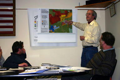
There were also some questions about how planning for the Etna area had turned out. Skip Thorne of the Etna Community Association was there, concerned about plans for development to the south and west of the hamlet. Planner George Frantz described the proposed changes to the south, removing the industrial area and adding a green buffer between Etna and Route 13, which seemed to go over well.

George Frantz shows how plans for Etna have changed.
As the board reached the agriculture section of the plan, Miller also objected to language restricting the kinds of businesses permitted on agricultural land, and a line about "crafty zoning language" that was apparently a typo for "crafting zoning language". The board ran out of time for discussion, and will discuss this in more detail in future meetings.
Posted by simonstl at April 20, 2004 08:46 AMNote on photos