January 30, 2005
Land use in Etna and the Town, 1966
After the introductory material on land use patterns, the 1968 General Plan goes into one of my favorite features: a building-by-building survey of the Town as a whole, with additional maps for Etna, Freeville, and Dryden.
The map for the Town as a whole includes some very tiny type, so I had to scan it at a higher resolution, producing a bigger file. This sample, at the western intersection of Routes 13 and 366, gives you some idea what it looks like:
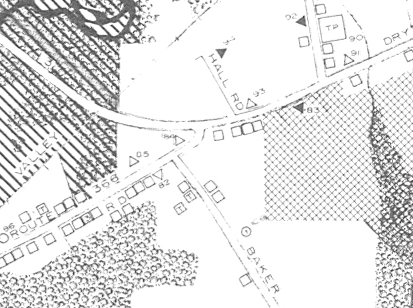
A piece of the map of Town of Dryden Land Use from the 1968 Dryden General Plan.
There's also a list of numbered buildings corresponding to the numbers on the map - #84, where Treeforms is now, is "Commercial (radio & t.v. sales & repair)", while #85 next to it is "Commercial (Boxcar) restaurant". Note that Wilcox Press wasn't there yet. You can get a pretty detailed idea of what was here (and what wasn't) in 1966, the year the field survey was done.
Land Use Pattern - Town of Dryden (93KB PDF, or 5KB text)
Photo on Map of Town of Dryden (2639KB PDF)
Land Use Map of Town of Dryden (2843KB PDF)
Photo on Map of Etna (2592KB PDF)
Land Use Map of Etna (486KB PDF)
The Etna map doesn't come with a list of places, probably because the few non-residential locations are identified on the town map.
Posted by simonstl at January 30, 2005 10:35 AMNote on photos