March 20, 2005
More on the Onondaga Land Rights case
Although I haven't heard much more detail about the Onondaga Nation's Environmental and Land Rights legal action since I first posted on it, and expect this will take years or decades to sort out, I have collected a bit more information possibly worth sharing.
(I am not a lawyer, and none of this story should be construed as legal advice of any kind. My maps are approximate, and my understanding of the law in this case is the kind you get from reading lots of news stories, not from reading law books.)
County Legislator Mike Lane shared a letter that Tadodaho Sidney Hill had sent him and other county legislators on behalf on the Onondaga Nation Council of Chiefs. I've scanned it in, and you can read it in PDF, either clearer (180KB PDF) or selectable (319KB PDF). In it, Hill explains what the Onondaga are seeking through this legal action, and two paragraphs seem especially important:
What does the Nation want from this Case? In two words, justice and healing. For over 200 years, we have endured hardship and indignities from the unjust taking of our ancestral land. We have been confmed to a small reservation. We have suffered the painful loss of our traditional way of life. We no longer can eat the fish that come fiom Onondaga Lake or from other lakes or streams because industrial polluters have poisoned their waters. Our ability to hunt has been illegally restricted. The land itself is contaminated by hazardous waste sites, abandoned industrial dumps, and other outrages that impact on our health and the health of our neighbors. Where once our people walked along the shores of Onondaga Lake and met in a sacred conclave with the Great Peacemaker, there now exists oozing pits of industrial debris that ruin the land and add new toxic burdens to the waters.
The Onondaga Nation brings this action not to obtain a casino. A casino could never compensate for the years of injustice endured from New York State Administrations. We want our neighbors to know there is no intent to take action against citizens living in Central New York. There will be no actions to evict our neighbors from their homes as we know all too well the pain and suffering displacement causes.
The Onondaga Nation seems intent on differentiating their case from others by calling it a "Land Rights action" rather than a "Land Claim," I think to emphasize that they don't plan to actually seize the land or sue landowners, but the underlying legal mechanisms are the same.
As I mentioned before, Dryden is in a part of the disputed territory that is slightly different from previous successful New York State land claims, because the treaty in which the Onondaga ceded the land was signed before the Nonintercourse Act of 1790. Other parts were ceded after the federal government had barred states from negotiating these treaties on their own behalf, and the case on those will likely find standing easily. For Dryden and much of the rest of the case, however, the court will have to decide if the legislature's failure to approve the treaty until 1813 makes it a violation of the Nonintercourse Act.
Lane also did some research in local history books, and found a map on pages 24 and 25 of W. Glen Norris' Old Indian Trails in Tompkins County that shows a pre-Revolutionary War boundary between the Cayugas and Onondagas that is somewhat to the east of the boundary the Onondaga Nation shows on their maps. I can't just reproduce the historical map for copyright reasons (it was made in 1944), so I've put approximations of both the Ononodaga line and the Norris line on to a map I created for an earlier story.
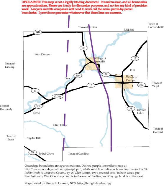
Town of Dryden map, showing two different Cayuga-Onondaga boundaries.
Norris' line in solid purple leaves much of Freeville and Etna out of the Onondaga area (marked by the dashed purple line), as well as parts of the Ellis Hollow and Yellow Barn Road areas. However, determining where the line really is will be a matter for surveyors, lawyers, and land title companies - Norris' earlier line is interesting, but doesn't necessarily have any connection to the terms of the actual treaty.
Norris also shows "traces of occupation" along the southern edge of Dryden Lake, on Hammond Hill, and in West Dryden, and a camp site on the north edge of Dryden Lake. Trails roughly follow present Routes 366 and 13 (old Route 13) from Varna to the Village of Dryden and on to Cortland, and other trails roughly follow Route 38 from Dryden to Harford and Irish Settlement Road.
NYCO also has more on the Onondaga story (and now more), as does Indian Country Today.
I'll post more as details become available, which I suspect will be a slow process.
Posted by simonstl at March 20, 2005 02:09 PMNote on photos