December 28, 2003
When Route 13 moved
Whenever I look at a map of Tompkins County, I look for the distinctively-shaped intersection of Routes 13 and 366. Even if a map doesn't have road labels, it stands out pretty clearly. It wasn't always that way, however - Route 366 through Varna and Ithaca used to be Route 13, until they built the new road through Lansing.
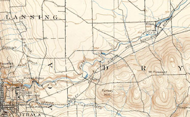
I found a 1900 US Geological Survey map of Dryden. This excerpt of it shows the road structures around Route 13's current path:
You can click on the map for a larger (452KB) version.
The map doesn't have road labels, but a few things stand out, notably that there were more direct connections between Dryden Road and Lower Creek Road. Freese Road stands out with its sharp curve, but Monkey Run Road and Baker Hill Road both had their own circuitous paths to Lower Creek Road. The area where 13 presently runs is largely blank.
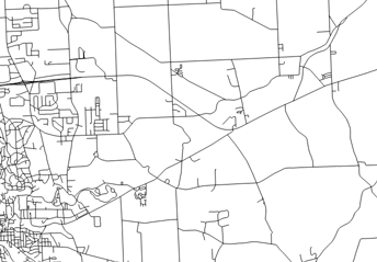
The current road map, taken from the Tompkins County Road Centerlines data, looks very different:
There's a lot more development, but the roads now focus on the new 13, and there are fewer crossings between 366 and 13 than there were between 366 and Lower Creek Road. Baker Hill Road now halts at 366. (A dead end stub of it runs to some buildings, but a No Trespassing sign marks its end quickly.) Monkey Run Road is shown going through, but that road is not in service - big plow turnarounds and gates lead to a wide trail. There's lots and lots of new development on the western edge of this map, though that's largely Lansing and Ithaca.
It's also interesting to note how the roads around Etna and over Mt.Pleasant have changed very little. (I don't think Mineah Road, the easternmost road on these maps coming south off 13, goes through currently, however.)
If you want to see this in a more recent USGS map rather than the unadorned centerlines, similar information (and a lot more!) is available in a 1978 USGS map.
Posted by simon at December 28, 2003 9:56 AM in Hanshaw Road , Route 13/366 , maps , roads, traffic, and transit , trailsNote on photos

