April 4, 2004
Introducing Dryden
I've had a few people (including some in the town) ask for more information about the town generally, in addition to the detailed information I'm providing in individual blog entries. This entry is intended to address those questions, and it will be updated on a regular basis whenever I get around to it.
The Town of Dryden has been on the map since the 1790s, when it was created as one of the townships in upstate New York's Military Tract, and named after poet John Dryden. Two hundred plus years later, it is a largely rural and suburban area between the cities of Ithaca and Cortland, and part of Tompkins County (map). It contains two villages, Dryden and Freeville, as well as a college, Tompkins-Cortland Community College (TC3), within its 94 square miles.
When it was originally surveyed, the town was drawn as nearly a square along the southern edge of the Military Tract. Seven of its hundred lots along the southern edge of the town were set off to Caroline in 1887, but otherwise the town has retained its largely square shape.
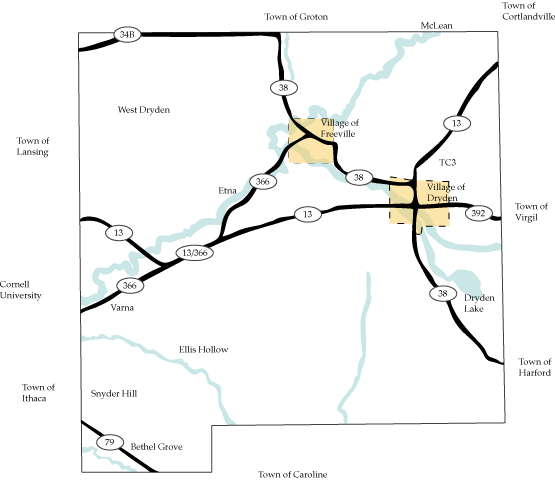
Town of Dryden map, showing state highways, villages, creeks, and lakes.
That shape straddles a number of divides, with forested hills in its southern reaches, part of the eroded Appalachian plateau, and more rolling terrain further north in the Great Lakes plains. The best farmland tends to be in the north and east of the town. Though there is scattered farming all over, many old Dryden farms which didn't have excellent soil are now state forest, privately held woods, or developed for other use. The entire area is loosely connected to both the Southern Tier region of New York and Syracuse. Dryden isn't far from the northern edge of the 607 area code, and the change in zip codes from 14 to 13 crosses the town. While most of the town is in the Great Lakes watershed, the southeast corner is in the Susquehanna River watershed.
The approximately 13,000 people living in Dryden are themselves divided in a number of ways. The hilly southern side of town tends to be in the Ithaca zip code and Ithaca City School District. To the north and east of the area where Routes 13 and 366 overlap are the Dryden Central School District, and the Etna, Dryden, McLean, and Freeville zip codes. Ithaca Journal newspaper boxes predominate in the southwest of the town, and Cortland Standard boxes in the northeast. The far southwest corner of the town, Bethel Grove, is also largely connected to Ithaca, but along a different state highway, Route 79.
Within the Town, there are two villages, Dryden (1,832 people in 2000) and Freeville (505 people in 2000). There are also several hamlets, which in New York means roughly "populated area without a municipal government of its own". Varna, along the western border with the Town of Ithaca, has about 679 people, while Etna, further north and east along Route 366, has about 379. The hamlet of McLean straddles the border with the Town of Groton in the northeast, and the Dryden side of it includes about 324 people. Other areas in the town with a distinct identity include Bethel Grove in the far southwest, Ellis Hollow to its north, and West Dryden in the northwest.
Posted by simon at April 4, 2004 11:11 AM in introducingNote on photos