February 6, 2005
Dryden's future? New comprehensive plan draft published
The Town of Dryden has posted a revised version of its Draft Comprehensive Plan. This is the one document I'd encourage everyone interested in the future shape of Dryden (including the villages, even though they're not included) to read. The Planning Board will be having a public hearing on this document February 17th at 7:15pm at Dryden Town Hall (map) Neptune Hose Company (map). After the Planning Board considers public input, it will go to the Town Board for further hearings and possible adoption.
The maps are probably the easiest things to look at, though it's worth emphasizing that the maps are not a direct template for the future. This plan does not specify how any of these things are to be implemented - that's up to the Town in future work, whether it's about zoning, road redesign, trails, or water and sewer systems. The lines on these maps have meaning only insofar as they inform those processes, not direct them.
If you click on any of these maps, it will take you to the PDF original on the Town's web site, so you can look at them in greater detail. (All of them are close to 300K each.)
The first map is the Future Land Use plan. Key features include hamlets in yellow, areas planned for suburban residential development in red, rural residential in brownish orange, commercial in pink, and industrial in blue. A thick yellow line indicates areas where Purchase of Development Rights (PDR) applications are underway, which may make those undevelopable except for agriculture. (Update: The PDR process continues; they're just not on this map.) The light green is agriculture, while the dark green is conservation and open space land.
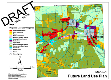
Proposed future land use in the Draft Town of Dryden Comprehensive Plan.
The striped area immediately to the west of the Village of Dryden is an 'agricultural reserve', which the Plan explains:
In addition to the lands designated for Suburban Residential uses in this Plan there is an area of approximately 910 acres of land immediately west of Dryden village that is designated as an Agricultural Reserve area. From an overall land use standpoint these lands are well suited for development as future residential neighborhoods. Yet at the same time they are high quality agricultural lands that are owned and farmed by families that are committed to continue farming their lands.
To balance these two competing interests the Town should treat these lands as if they were designated for agricultural uses and apply the actions and policies recommended in the Agriculture section below to these lands. Not including these lands in the "development" land use categories will not have any measurable impact on the Town of Dryden's ability to accommodate all expected future growth and development. In future decades, however, should their use for agricultural purposes be abandoned then they can be treated as other lands in the Suburban Residential category.
There is also a "Route 13 Overlay" area that covers a part of the town that has had conflicts over the mix of residential and commercial development. The plan (on pages 62 and 63) sees the overlay area as remaining mixed, but encourages the Town to develop standards for this area that will protect residents and prevent traffic congestion.
The next map of Dryden's possible future shows potential park and trail locations, as well as places where intersections need to be reconsidered. This map has changed substantially from its predecessor. Oddly, just as the Town considers putting park land next to Town Hall, the asterisk showing a park there moved out to the east. This map also shows a lot more proposed trails than its predecessor, many of them following powerlines across the town. Most of the new trails will be more primitive trails, not the more heavily-built trails that run over railroad beds. I'm intrigued, and wish those trails were more accessible to my house, but I'm sure there will be a wide variety of opinions on the subject.
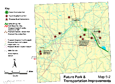
Proposed future park and transportation improvements in the Draft Town of Dryden Comprehensive Plan.
For much more information on the trails and parks shown in this map, see pages 68-76 of the plan.
The last map of the future Dryden is the map of possible water and sewer service. It shows areas where development and proximity to existing water and sewer systems make further development economical. Readers in the villages of Dryden and Freeville should definitely take a look at this, as their systems may expand over the long term to support this potential development. Some people will probably just see rising costs, while others will hope that this spreads existing costs over more people. There's a lot to think about.
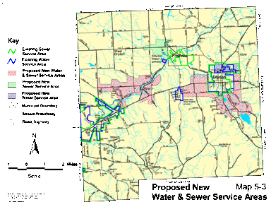
Proposed new water and sewer service areas in the Draft Town of Dryden Comprehensive Plan.
I haven't had a chance to read the complete new draft yet, but I'll be doing that and writing more about it here over the next week. I'm especially interested to see how the sections on hamlets and agriculture turned out, as those were two of the most contentious. (I'm especially happy that there is a version highlighted for changes.) If you'd like some background on this document, you might try the planning and zoning archives of this site.
Posted by simon at February 6, 2005 1:31 PM in planning and zoning , recreation , roads, traffic, and transit , trailsNote on photos