February 21, 2006
Soil survey maps
There's a lot of discussion of soil types at Town Hall. Soil types affect everything from agriculture to septic tank placement to erosion and runoff. The Town of Dryden Comprehensive Plan includes Map 4-1, Natural Constraints to Development (1.9MB PDF), which is a combination of soil type and floodplain data. It's a useful map if you want to know where the best agricultural soils (Class I & II) in town are, and where it's too swampy to build. It doesn't, however, have the detail of the USDA Soil Survey from which it's drawn.
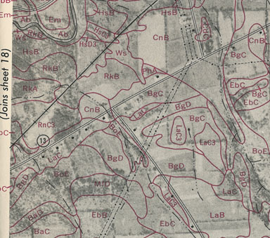
I'm planning some fairly large changes to my lawn and garden over the next few years, and when asked about the soil type, I responded "Clay, with lots of rocks." As I learned from the Series 1961 Soil Survey of Tompkins County, New York, however, my soil isn't all that bad. The maps of soil locations, superimposed on aerial photographs, are astounding:

Soil survey map for the intersection of modern Route 366 and Baker Hill Road.
The maps are interesting in themselves, as they reflect the road system before Route 13 moved. Current 366 through Varna and Ithaca was old Route 13. The aerial photos are also dated, showing the current forest across from my house but empty pasture lined with the occasional tree behind it. Of couse, there also aren't so many houses, and there's a railroad track, but the powerlines seem to have stayed in the same place.
My house - the second building to the east of the Route 13 marker - turns out to be on LaC soil, Langford channery silt loam, with slopes of 3 to 8 percent, a Type III soil. The land behind me is BoE, Bath and Valois soils, with 25 to 35 percent slopes, "too steep to be cultivated safely with modern machinery," where "erosion would be a very serious hazard" if the soil was plowed.
My LaC soil has a depth of 12 to 18 inches before hitting the fragipan, a dense layer of soil that isn't very permeable. Above that fragipan it drains well, and is fairly acid. Unfortunately, it's soil that's already eroded, having lost 4 to 6 inches in the past, increasing spring moisture and supplying fewer nutrients.
I have a lot of work to do in the garden, but really marvel at the people who went out and sampled all this terrain to produce these maps. It's fairly hard to imagine teams of people with shovels visiting the whole county, though my understanding is that it was done during the depression.
(Unfortunately, the very cool looking NCSS Soil Survey online maps report that they have no data for Tompkins County.)
Posted by simon at February 21, 2006 8:34 AM in agriculture , maps , permaculture , planning and zoningNote on photos
These are truly amazing documents, largely created before the advent of computers, GIS and GPS systems, and satelite imagery. I was trained as a soil scientist so I had the privilege of working with some soil scientists that contributed to this effort. Some surveys were in fact created in the 30's and before, but the more taxonomically correct documents were created by teams in the 60's and 70's - Onondaga Co. for instance. Its interesting to note that despite the amazing comprehensiveness of a given survey, something less than 1/10th of 1% of any given soilscape is really ever sampled directly. Instead much of the identified patterns rely on the underlying geomorphological correlations. Esp. in New York State, a soil survey is a great resource for identifying the geomorphological features and glacial history of an area.
And speaking as a soil scientist, you should also keep in mind that the primary focus of a USDA County Soil Survey is agricultural. This is something us Stumpy's tend to gripe about since surveys tend to undersample non-agricultural, forested areas, lumping everything together with names like "Lordstown Soil". So while definitely useful for environmental planning, wetland delineation or septic siting for example, they still have their limitations - to be used for guidance not as absolute "truth".
Still, very cool - you'll always get me commenting on soil and water posts!