May 24, 2006
A closer look at the bike map
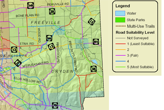
Earlier this morning I noted the work of the Ithaca Tompkins County Transportation Council (ITCTC) on a draft map for bicyclists indicating the suitability of various roads in the county for bicycling. Here's a closer view of the portion of their map (1.9MB PDF) for Dryden.

Draft map for bicycle suitability in Dryden.
You can click on that map for a larger image, which is probably a good idea.
I'm still getting started in bicycling, but I guess I have to wonder about the "average" cyclist in the map criteria (91KB PDF), at least for the stretch of 366 I ride. True, the speed limit is supposed to be 45mph, and the shoulders are usually wide, but there are also passing zones, unpredictable shoulder use for driveways, narrower sections, oversize loads, and the always cheerful concrete and gravel trucks. Add to that heavy traffic during the time periods the ITCTC seems most likely to want to encourage bicycle traffic, and I'm not particularly convinced it deserves a rating of 4, comparable to Irish Settlement or Snyder Hill Roads. Maybe with some bicycle signs and markers in the shoulders?
See what you think about the other roads, too.
I can't make it to tomorrow night's meeting, from 6:00pm to 8:00pm at the Old Jail (map) in downtown Ithaca, but hopefully other people interested in bicycles can.
Posted by simon at May 24, 2006 8:34 AM in bicycling , mapsNote on photos