While the zoning process is sort of technically the "implementation of the Comprehensive Plan", there are many changes from the 2005 Comprehensive Plan to the 2010 Draft Zoning. Some of that is to be expected, but I think it's still worth highlighting some of the more dramatic changes. (It does, unfortunately, take a lot words to do that, so the details are in the extended section.)
In some substantial cases, I don't think pointing to the Comprehensive Plan and calling the zoning an implementation still holds.
The commercial zones are no longer recognizable as anything specified in the Comprehensive Plan. I'm not sure what happened there.
The overlay districts in the zoning are more or less complete innovations.
The residential and hamlet zones in the current draft of zoning don't begin to manage density with the precision suggested by the Comprehensive Plan, but still sort of look kind of like what the Comprehensive Plan said. (Work getting started on the hamlet zone will likely lead toward something more like what the Comprehensive Plan suggested.)
Conservation and agricultural areas are generally more loosely regulated by the draft zoning than the Comprehensive Plan, but follow the same broad outlines.
The light industrial/office proposal has seen very few changes between the two.
The Comprehensive Plan listed 10 land use types, while the Draft zoning has six plus two overlay types. Roughly comparing the two, here's how they break down:
| Draft Zoning | Comprehensive Plan |
|---|---|
| Commercial (CC) | Retail Commercial |
| Route 13 Highway Corridor Overlay | |
| Rural Residential (RR) | Rural Residential |
| Suburban Residential | |
| Hamlet (H) | Hamlet |
| Conservation (CV) | Conservation/Open Space |
| Rural Agriculture (RA) | Agricultural |
| Agricultural Reserve Area | |
| Light Industrial/Office | Industry/Office/Research |
| [No equivalent] | Institutional |
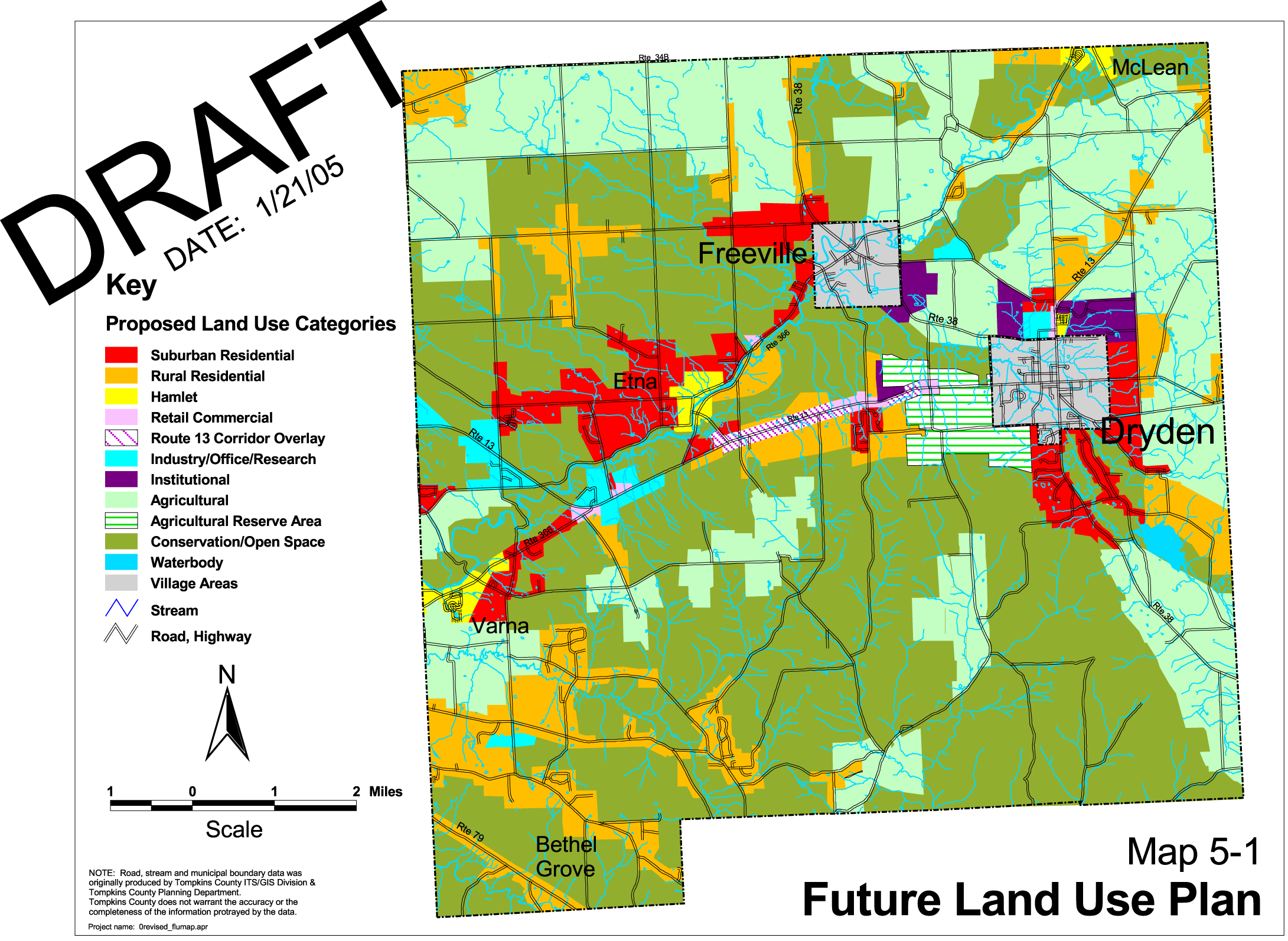
I'll talk more below about the changes to specific land use categories, but the map also has some substantial changes worth noting first. (You can see the new map as an image or PDF, and the Comprehensive Plan map as either page 51 of the plan or in this image.)
The hamlet areas used to include Varna, Etna, McLean, and the area north of the Village of Dryden. Now it's just Varna.
The "institutional" marking for TC3, Dryden High School/Middle School, George Junior Republic, and Willow Glen Cemetery has disappeared. George Junior and TC3 seem to be in Rural Agricultural, the High School/Middle School in Rural Residential, and the cemetery is in commercial.
The "Agricultural Reserve Area" is now mostly Rural Agriculture with a spot of commercial.
Some of the areas formerly marked Suburban Residential or Hamlet around Etna and the Village of Dryden are Rural Residential with an Optional Traditional Neighborhood Development overlay.
Agricultural areas along Irish Settlement Road in the Comp Plan map are now Conservation.
The Rural Residential area near West Dryden expanded out into what used to be Conservation/Open Space.
The Industry/Office/Research area along 13 expanded into a lot more of what had been Conservation/Open Space.
The most drastic changes happened in the commercial areas. The Comprehensive Plan described Retail Commercial as:
The Future Land Use Plan envisions only a small increase in the amount of land dedicated to commercial retail and service enterprises. The type of commercial development that this plan envisions would be a continuation of the pattern that exists in the town today, specifically small neighborhood-oriented businesses providing goods and services to a primarily local market. Commercial development that is out of scale with existing businesses should not be encouraged in Dryden.
In these areas agriculture is also expected to be an appropriate land use and should be permitted in any future zoning regulations. (60)
Agriculture is mentioned, but residential development is omitted completely. Not only that, but the section on the Highway Corridor Overlay notes:
The Rte. 13 corridor between Irish Settlement Road and Etna Lane poses a particular planning challenge. High traffic volumes adversely impact the utility of land adjacent to the highway for residential development. Also as the corridor experiences further development in the future, there is the potential for substantial increases in the level of congestion on Rte. 13 unless steps are taken now to control that potential.
The conflicts that have occurred where commercial and industrial development has occurred in close proximity to residences are an ongoing land use issue within the corridor. In several instances long-time residents of the area have been adversely impacted by new non-residential development adjacent to their properties. These newer industrial or commercial enterprises are seen as exacerbating the impact of the heavy traffic on the road. (61)
The Overlay doesn't propose banning residences from this area - it is, after all, bounded on the north and south by Rural Residential with no other access to the highway. Instead, it suggests very careful planning to create a mix of uses more compatible with each other and with the busy highway:
Although the envisioned resident and non-residential land uses such as retail, office, services and research and development businesses are not compatible, they can still occur adjacent to or in relative proximity to each other without adverse impact to the quality of life in future residential neighborhoods. This is easily accomplished by establishing ahead of time standards to guide residential and non-residential development. (62)
To make this work, the Comprehensive Plan talks about limiting curb cuts, encouraging shared driveways, requiring visual buffers between uses, large setbacks from the road, and limiting heights of buildings to two stories. The Draft Zoning pretty much runs the opposite direction in every way possible:
The map expands the space available for commercial development by at least four times what the Comprehensive Plan suggested.
Many of the commercial areas newly marked on the map are along state highways, mostly Route 13, in high-traffic areas, where the problems encounters in the overlay area are likely to repeat themselves.
Dense residential development, up to 10 dwelling units/acre, is allowed in any commercial zone where water and sewer are available. (I don't think the zoning itself limits dense development to areas with water and sewer, but it would require a Special Use Permit and Tompkins County Health Department approval, so I suspect that limit is effectively there.)
Front yard setbacks shrink to 40' from the existing zoning's 70', with no mention of the Comprehensive Plan's suggested 200' for residential development.
Residential buildings of up to three stories and 35' are explicitly allowed.
There's nothing specific about curb cuts and shared driveways in sections that apply to commercial zoning.
It's very difficult for me to square the vision of the commercial zone in the current draft zoning with anything in the Comprehensive Plan, and as I've noted before, it seems like a recipe for lumpy sprawl to me. If substantial development actually happens in this area according to these loose rules, I forecast a lot more waiting in traffic along 13 in particular.
The Optional Traditional Neighborhood Overlay (OTNDO) and the Large Scale Retail Development Overlay (LSRDO) in the draft zoning are completely new. OTNDO sort of resembles Suburban Residential, but is applied very differently, excluding places that have water and sewer infrastructure. LSRDO actually contradicts the plan, which said simply that:
Commercial development that is out of scale with existing businesses should not be encouraged in Dryden. (60)
While LSRDO is specified in the text, it's not on the map, however.
The Comprehensive Plan described two land use categories, Suburban Residential and Rural Residential. The primary difference was density, with Suburban Residential averaging up to four dwelling/acre, with possibilities for greater densities of up to 10-15 units/acre, and Rural Residential limited to one unit per two acres. The draft zoning squashes both of these into a single Rural Residential zone with a 4.35 unit/acre limit in places where public water and sewer are available, and a 1 unit per acre limit elsewhere. (Update: This has changed with the separation of Rural and Neighborhood Residential, though the proposed densities remain the same.)
(I'll have to write later about Sections 601 and 602 regulating permitted density. I have to admit that I don't entirely understance them - there's a limit of 1 dwelling unit per 2 acres of parent parcel overall, as well as the densities I calculated above based on minimum lot sizes...)
Interestingly, the Suburban Residential description not only doesn't expect such a squashing, but states:
The Suburban Residential areas shown on Map 5-1 are not proposed zoning districts and should not be viewed as such. In reality the proposed Suburban Residential areas of the town are expected to encompass a number of different types of residential zoning districts. These new zoning districts will govern the types and densities of development allowed. For example there may be a district that allows single-family homes on lots as small as 10,000 square feet; one that requires a minimum of 20,000 square feet per lot; and one that may require lots one acre in size or larger, probably at the periphery of the Suburban Residential area.
As is the case in many municipalities, multiple residence development in the future could be accommodated in Dryden through a discrete zoning district. Such a district would set a maximum density in terms of the number of dwellings per acre allowed, maximum height of structures and minimum parking requirements. In addition such a district should also include specific requirements for building setbacks and buffer areas, maximum lot coverage by impervious surfaces and standards for the amount and quality of open space available for use by residents. (50)
That shift from precise zoning to broad districts echoes a lot of the complaints Varna residents have raised about the Hamlet zoning, and the Town seems to be addressing those.
The largest shift in the hamlet zoning comes in the map, of course, as this shrank down just to Varna. As in the Suburban Residential area, though, the Comprehensive Plan forecast a zoning process more like the attempt the Town is making to improve Varna's zoning than like the text currently in the draft:
The residential development density proposed for the hamlet areas is a maximum of 4 dwellings per acre. As with the Suburban Residential areas of the future, the Hamlet areas would be comprised of several types of residential zoning districts with varying maximum allowed densities. Multiple residence zoning districts could be appropriate within the Hamlet areas. Mixed-use zoning that would allow, for example, apartment-style residences above ground floor commercial space would also be an appropriate land use tool. To maintain the balance between home ownership and rental housing and to prevent rapid change in the hamlet character, multiunit developments should be limited to a maximum of 20 units.(52)
The current draft of the zoning, which I expect won't stand, includes §605 on page 31, which allows up to 10 units per acre anywhere in the hamlet, with limits per building, not development. (There's a limit of 16 units per development on Multi-Family detached, but the rest of the limits are per building.) There's no attempt to differentiate parts of the hamlet for different uses, though the use table does reflect the mixed use vision of the Comprehensive Plan. (Oddly, it requires Special Use Permits for auto repair in an area whose thriving businesses have largely been auto repair shops.)
The general idea behind the conservation areas remains - there are natural areas worth preserving in the Town, often in places that aren't ideal for building in any case. The Comprehensive Plan had proposed a simple if draconian sounding approach to development in these areas:
Even at one dwelling per ten acres, there is still potential for over some 2,000 dwellings within these areas. Residential development will still continue to occur, albeit not at the same levels as possible in the past.(69)
It also mentions agriculture as a use but proposes that "other more intense land uses such as commercial or industrial uses, quarrying and other extractive industries should not be allowed."
The draft zoning is substantially more permissive about uses in Conservation zones than it is for Rural Residential. The only cases I can find where things are allowed in RR but not in CV are day care centers, manufactured home parks, and senior housing, while there are seven uses possible in CV but not in RR.
The draft zoning allows the same minimum lot sizes as the Rural Residential zones, but requires the use of Conservation Subdivision and sets a limit of one dwelling unit per 2 acres of land in the parent parcel. I have to admit that I've not yet been able to figure out how Conservation Subdivision really works, but will attempt to figure it out and explain it sometime soon.
The zoning shifts from the Comprehensive Plan less in the agricultural zones. The Comprehensive Plan spent a lot of its prose talking about ways to protect farmland through non-zoning approaches, a farming advisory committee I don't believe has ever appeared, and the need to protect barns. There is some discussion of one dwelling per two acres, but also of clustered housing at higher densities with preserved land beside them. For the most part, the zoning is similar in its suggested uses, though it does allow the same density as Rural Residential: one unit per acre or up to 4.35 units per acre in areas where public water and sewer are available.
As noted above, the "Agricultural Reserve Area" disappears, though since developers can build to Rural Residential densities, it may no longer be necessary.
I don't see much change, other than the map, between the Comprehensive Plan's vision for Industrial/Office/Research and the draft zoning's vision for Light Industrial/Office.
Posted by simon at September 10, 2010 11:13 PM in planning and zoning
Simon,
I'll say it like I have said it all along: Writing a law is completely different from writing a plan. And, the Comp. Plan was far too specific.
Thanks for the comparison though, it certainly provokes thought.
Simon,
You're missing the fact, relative to commercial, that there are now Commercial Design Guidelines in place. You can't reasonably predict what is going to happen from the code alone, the market plays a much stronger role.
As for commercial area, you seem to have not accounted for the Route 13 Overlay (a perfect formula for sprawl). It is a much smarter strategy to use the side roads that exist as feeder roads to Route 13 rather than locate on Route 13, which does follow the current pattern.
There is certainly more work to do in this area. Most importantly, I think people are confusing their own image of commercial with what the law intends to allow, which is more of a local service nature commercial.
And yes, water and sewer availability will dictate the possible for a long time. I think the law a this point generally reflects the reasonable maximum without municipal water and sewer.
Again, thanks for the analysis, but you have to look at all the pieces, not just the law. The law is the minimum standard, the design guidelines are the expectation.
Hmmm...
First, the Design Guidelines, whose name gives away what they are. They aren't particularly enforceable any more than the Comprehensive Plan is. Larry Fabbroni made it pretty clear at the Planning Board when he and Stephen Lucente were introducing Varna II take 2 that they planned to blow right by the Design Guidelines - and no one batted an eye.
It's certainly something the Town Board and Planning Board could point to if they wanted to, but that's going to depend on their future makeup.
Second, the market. Of course the market matters, but when comparing plans with plans, it's something that has the same effect on both.
Next, the Route 13 Overlay, which you seem to think I missed but gets quoted a lot above. Did I say it was perfect? No, of course not. What it did - and what the current commercial zoning utterly fails to do - is acknowledge a problem. The commercial zoning in the current draft is, so far as I can tell, as recipe for spreading those same problems much further along Route 13.
I'm not sure how you think people are confused about commercial - so far as I can tell, "commercial" started out meaning the "local service nature commercial" you mention but has since morphed into a "small-to-medium businesses plus high-density residential" mixed use zone.
I'd strongly encourage the board to figure out a name that describes the zone accurately, or to break that multiple-meaning zone into more describeable parts.