July 1, 2011
Gas lease map revisited
If your first response to the news that the state will be allowing hydrofracking around here is "what does this mean for me?", you're not at all alone. Between the patchwork parcel-by-parcel of gas leasing and the state's compulsory integration rules that encourage drilling where there are concentrations of leases, it's hard to forecast how this will go.
However, there is some information available, thanks to the Marcellus Accountability Project, which dredged through lease information a few years ago. Wading through that much information and tabulating it into maps is itself a heroic project, one I can barely imagine taking on. Their underlying map doesn't appear to have been updated much, or updated at all since February 2010, update and I've heard of some imperfections. However, it should give you a rough idea of the leasing situation.
[The rest of this is a reprint of Gas lease map, from August 2009.]
Talk about gas drilling is often pretty abstract. Signing a lease doesn't put a sign on the land saying "this land leased for gas drilling", and figuring out what has been leased can mean a long trip through stacks of deeds.
Today, though, you can take a look at what's been leased in Tompkins County, thanks to a new gas lease map from the Marcellus Accountability Project. The data was collected by hand, and there may have been changes over time. They do provide information if you want to go looking for more yourself.
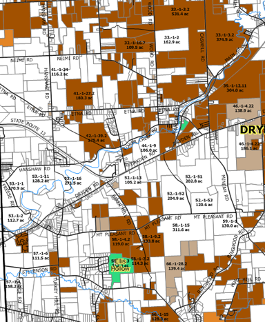
In my immediate neighborhood, just west of the Route 13/366 overlap, there isn't very much leased, except The Orchid Place and Autoworks. (White is unleased. Dark brown means surface rights are included in the lease.) Down the road in Varna, Hillside Acres is leased.

Gas leases along Routes 13 and 366 (approximately).
I worry that that map may understate the leases around the Route 13/366 overlap, as Angelika was looking for possible orchard land in some parcels marked "unleased" there - but the owner made clear that he'd sold rights.
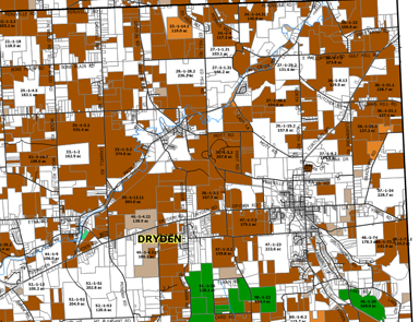
The area around the Villages of Dryden and Freeville is pretty heavily leased:

Gas leases around the Villages of Dryden and Freeville (approximately).
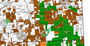
The southeastern hills are a mix of leased land and green state forest, making the state's decisions about its property seem extra-important.

Gas leases in the southeastern corner of the Town of Dryden (approximately).
Another sign making it a lot less abstract is a field services company "setting up a $30 million outpost" down the road in Horseheads.
Posted by simon at July 1, 2011 7:43 AM in energy , mapsNote on photos
Also, presenters from the Tompkins County Council of Governments Task Force are giving a presentation on what Gas Drilling would look like in Dryden. The presentation is JULY 12 at the VFW. It starts at 7:00pm.
We will be able to see aerial views of landscapes in states where drilling is active.
Envision where well pads might go in Dryden.
See well placement as they relate to houses, streams, schools, etc.
And understand how access roads and pipelines affect the landscape.
This informational "Mapping Project" is a result of planning done by the Tompkins County Council of Governments and is presented for the purpose of getting current information to Dryden residents.
Thanks, Rick! That was my next planned post! (Well, I may sneak in the fireworks for tonight.)
Nice work collecting all of this data. I work for a center in PA that manages an online and public data storage and mapping system called FraTracker. Would you be interested in contributing this lease info into the system? If so, check out http://data.fractracker.org.