February 8, 2005
Land use in the Village of Freeville, 1966
The survey in the 1968 General Plan for the Village of Freeville continues to be amazing, again listing use for every parcel as it was in 1966. This graphic shows an inset concentrating on the now vanished railroad tracks in the northeast end of town:
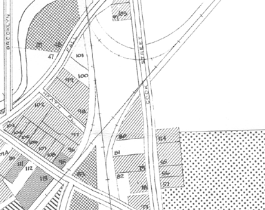
A piece of the map of Village of Freeville Land Use from the 1968 Dryden General Plan.
Again, as there was for the Town and the Village of Dryden, there's also a list of numbered buildings corresponding to the numbers on the map - #83 and #84 were a lumberyard, hardware, and appliance store, while #48 is listed as Commercial (farm equipment and auto repair, junk yard, residence trailer).
Land Use Pattern - Village of Freeville (80KB PDF, or 4KB text)
Photo on Map of Village of Freeville (2407KB PDF)
Land Use Map of Village of Freeville (1067KB PDF)
Note on photos