April 25, 2007
Wow. Awful plan.
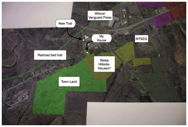
People in Dryden frequently complain when you threaten to put a trail across their property. I was happy tonight to see that the Route 13/366 Corridor Study plan shows a new trail going across my lot, something I'd never have thought would happen. There's even a nice connecting trail (a boardwalk?) through the Cornell Plantations swamp across the road to reach the railroad bed that should someday be a trail.
People in Dryden also tend to complain when they see a map that suggests a road going through their house. I'm not thrilled about that, but I'm deeply confused when my property is highlighted as a connection between residential housing on the steep slope behind my house and Route 366. They didn't notice, say, on the Town of Dryden Comprehensive Plan's map called "Natural Constraints to Development", that it's really steep back there? Slopes of greater than 15%? And for a long distance? This seems really unlikely to happen.
It's hard to know where to begin to discuss what's wrong with this plan. It starts with good intentions of nodal development, but then scatters housing on hillsides, puts more housing near (not quite in, if I'm reading the map right) swamps, and builds a new node on the 13/366 overlap east of where the existing node already is. There's almost nothing shown on these maps about building on to the existing Varna node, and the planners' talk of dense development on empty parcels doesn't exactly increase my confidence. Although they were happy enough to mark other open-seeming parcels for development, they left alone the Cornell research field at the corner of 366 and Game Farm, even though I suspect it better fit their criteria - and is better connected to an existing node - than the random hillsides they highlighted. (The same is true of other Cornell fields around Varna.)
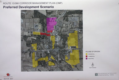
I don't know enough about the Village of Dryden to comment on their markups for that, though I know that the Village was at one point planning major expansion in its northeast corner and abandoned it largely because of wetlands issues. Maybe those issues have faded enough to put a connector road through from Lee Road to 392, but it still seems like a stretch to me. There may well be more room in the southwest for housing.

Proposed changes in the Village
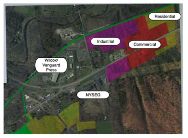
There may be discussion in the actual written plan - which wasn't distributed at the meeting - discussing ways to expand existing nodes in 'downtown' Varna and at the corner of Routes 13 and 366, but what the maps seem to show is the creation of a new industrial / commercial / residential zone along the Route 13/366 overlap. I'm not entirely sure what they think is the allure of that spot - while the existing node is largely in the new Empire Zone, the area to the east is pretty empty, with some roadside development, but the Comprehensive Plan pretty deliberately left a corridor of open space in there as a break along Route 13.

Proposed new node on 13/366 - top right
I have a hard time imagining who will want to be the pioneer businesses and home builders in that area. Yes, it's near a water district - Vanguard Press (formerly Wilcox Press) has water, but the Pinckney Road water and sewer district still hasn't taken off, and making this expanded node work will mean creating a large new area in a place that isn't yet served by water. Even if the Pinckney Road districts come to pass, the commercial development will likely stay further west, as that area isn't completely filled in.

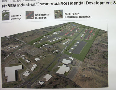
Illustration - proposed new node on 13/366
Then there's the looming question of the looming NYSEG building, a fortress built with its own cafeteria, water, and sewer systems, surrounded by a moat of parking lots and fences. All I heard was hope that it would somehow revive - after all, NYSEG's looking for tenants - and provide extra energy for this new eventual node.
I wasn't entirely enthusiastic after the initial public meeting, but it's especially strange to see how little connection I saw between that meeting's conversation and the resulting plan. I'm sure it all fit in somehow - or did it?
The Town of Dryden Comprehensive Plan was a huge pain to create, but it was very clear that the people creating it understood the terrain, the history, and the people affected by their plan. This Corridor Plan demonstrates no such understanding. While its drive for more housing is admirable, its path to get there is broken, broken enough that I have to question the competence of the creators of this plan. They apparently didn't see steep slopes or find out why certain places haven't been developed. They seem to think that zoning in a new node will create it, despite mixed results for development near that area.
I hate to say this, but I strongly recommend that the county and the planners scrap this plan. They can try again if they want (and I'd like them to), but this plan is broken, too broken to provide useful guidance for future development along the oldest corridor in Dryden. Building a better plan requires examining how new development meshes with old development, not just looking for places to drop more buildings.
(I would, however, love to see that bit of trail happen, and I'm happy to talk with planners about it.)
If you'd prefer to make up your own mind, I've posted a gallery of the maps and some other photos. I've made the full-size images larger than usual so there's a better chance of capturing detail. And definitely, please comment.
Posted by simon at April 25, 2007 10:31 PM in Route 13/366 , Village of Dryden , nodal development , planning and zoning , roads, traffic, and transitNote on photos

I'm wondering what kind of research these planners did, before they came up with their plan.
I can't remember anyone involved in the planning took the time to visit during the last months in order to personally inspect that 15% sloped prime resedential building area behind our house. (Really, our dog seldom bites, unless you drive an UPS-truck.) Probably, our local planners are busy people and can't be required to personally look at every house they want to replace with a road, so I shouldn't gripe about the lack of visitors. However, apparently they also didn't bother to look at the maps the Town of Dryden provides, either. It would have taken them about 5 min to learn, that the land is too steep for building purposes. Are our local planners that busy, or does the word 'sloppy' apply?
Wow! Seems like these people could use more practice with Sim City. I'm sorry I missed the presentation. I need to know a lot more about this. Who was there from the Planning Board?
I would urge everyone to realize, first, that this is a work-in-progress.
Second - and this is really important - the main point of this study was NOT what the nodes themselves would look like, but what are the differences between the projected build-out under the current zoning vs. build-out under a nodal development plan. (Those maps were part of the display on Wednesday night but Simon hasn't commented on them or on this point.) The study provided solid data to show that SOME kind of nodal development, as opposed to continued sprawl along the corridor, will be far more conducive to transit use, maintenance of Dryden's rural character, and other goals of the town. The presentation of the maps and graphics about what the nodes would look like is a minor part of their scope of work. They only meant to show that IT IS POSSIBLE to configure the nodes to incorporate the amount of development acreage as envisioned by the Town comp plan.
Many of Simon's comments have already been made to the consultants (such as housing on slopes that are too steep to feel part of a "walkable node"). I absolutely agree with that one and have already made my comments loud and clear! I understand they're working on changing this for the next set of graphics.
I think the "NYSEG node" shows real promise, with far more flexibility than we'd have in trying to intensify "downtown Varna." There were lots of constructive ideas at the open house about ways to improve on the design as shown, and I'm confident that the next iteration will be far more attractive and workable.
There is a lot going on with the Empire Zone and NYSEG that can be integrated into the vision for this area, and we should absolutely not pre-judge it at this point. For example, infrastructure could be extended relatively easily to the east of Pinckney Rd. If there were a clear vision about WHY to do that (which there has not been so far), I think the district would make sense. I'm convinced this area has very exciting possibilities; honestly, this node needs its own design study.
I don't have time to respond to each detail Simon raises, but I will say that the parcel at the corner of 366 and Game Farm just isn't big enough to do all that the NYSEG node could do. And everything I've heard from Varna residents over the years is that they are wary of too much development right in the hamlet, as it could easily overwhelm the neighborhood feel that they have and value. I agree with that.
The consultants will take all the comments from the open house and bring back a revised presentation to the study team. Stay tuned for an improved next draft.
Mostly, I hope the main message of the report will not be lost: The existing sprawl-type development will lead to an even more dangerous and unpleasant Rt. 13/366, and we should make decisions now that will allow and encourage nodal development instead.
Thanks for the comments, Martha. I'll be writing more about this plan over the weekend, but there are a few things worth noting here.
Yes, it's a "work in progress". However, the process summary showed this as the last phase of public input.
It's hard to comment on the rest of the plan, since I don't believe the rest of the plan is publicly available. Some pieces of the puzzle are on the Web, but there's no sign of what the rest of the report might contain.
The lot at 366 and Game Farm is too small for huge development, true, but it would be an excellent spot for concentrated housing with immediate - easily walkable - access to Cornell. That it and the other Cornell research fields surrounding Varna weren't even listed as options for development seems like a major oversight in a plan purporting to strengthen nodal development.
(While Varna residents haven't been thrilled with past plans for doubling the size of the hamlet instantly, I don't get any sense that they're opposed to all development.)
The contrast between the dreadful things that will happen if nothing is done and a better scenario would have played a lot better if the 'preferred scenario' looked preferable. Unfortunately, it looked like it was developed by people who don't know a whole lot about the area. That's not a great way to put the message across.
The other strange thing, which I hadn't noted in the original piece, was that for a study about a road, there was almost nothing done to the road. A few dividers and some (probably not so helpful) traffic circles were all that really changed about the road.
More later...