December 6, 2010
The Route 13/366 Corridor Study and the Proposed Commercial Zone
When it appeared, I pretty much loathed the Route 13/366 Corridor Study. It was a zoning plan that pretended to be about traffic, with an outcome I think I can describe as predetermined at best by the dreams of the County Planning Department. Public input seems to have been structured primarily to justify what the planners wanted to do anyway.
(And no, I can't say that being told that the best use for my house is as a driveway to apartments mountain goats might enjoy inhabiting particularly improved my opinion of the plan. Of course, since they didn't seem to survey the terrain or listen to the residents...)
That very lack of listening is useful in some ways, though, as it gives the Corridor Study a strange abstract power, representing an unadulterated call for "nodal development".
So what did the Planners suggest?

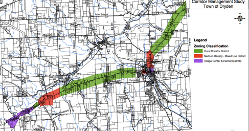
One vision of planning for Dryden's central highway core (From this original PDF).
The purple is village and hamlet development, and the red is what they saw as a mixed use commercial core. All of it is within easy access of both highways and water and sewer, and their proposal included mechanisms for dealing with the traffic they would create in those locations. The green, however, is "rural corridor district". That's not a "do not build zone", but heads that direction:
The area outside of the nodes can still be described as rural in character. Currently there are a variety of land uses scattered along the roadway including agricultural, residential, commercial, and industrial operations. It is recommended that zoning and regulatory provisions be put in place within these areas that preserve the low density of land development. In order to accomplish this, the Town should consider creating a Rural Corridor (RC) District....
The purpose of the Rural Corridor (RC) District is to support the goals, objectives, and policies adopted as part of the 2006 Comprehensive Plan. More specifically, the RC District is intended to allow the development of a variety of uses including residential, commercial, and industrial activity in a manner that preserves the undeveloped nature of certain areas along NYS Route 13. In order to accomplish this, the RC District regulates the location, design and use of structures and land to create a low concentration of activity in a rural setting and to ensure the safe and efficient movement of vehicles along the corridor.
Permitted Uses
The following uses are to be permitted within the RC District:
- Farming Operations
- Public & Semi-Public (private schools, fire halls, etc) uses
- Parks, Recreational Facilities, etc
- Single-Family Residential
Specially Permitted Uses
- Retail & Service
- Office
- Automobile Repair
- Warehousing & Storage
- Outdoor Storage
Note the total absence of denser housing possibilities in those uses, and the restriction of even many commercial uses. The idea here isn't to string dense housing along the corridor if water and sewer can reach them, but to keep this part of the highway corridor flowing smoothly.
Instead, the commercial zone now includes most of that "Rural Corridor" area, losing the distinctions the 13/366 plan made between the Rural Corridor and the possible nodes (Route 13/366 by NYSEG, Varna, and Dryden).
I think the proposed zoning wants to make a node possible by NYSEG, like that shown in Figures 16-19 of the plan (4.7MB PDF), but it doesn't pause to create any distinctions. It allows a wide variety of uses instead, hoping that developers and infrastructure managers won't do anything too awful along Dryden's busiest artery.
I worry that the mixed-use concept may have been promoted by the flawed Route 13/366 study, but somehow it became much more awful as it lost connections with what that study was trying to accomplish. The contrast is pretty bleak.
Posted by simon at December 6, 2010 4:56 PM in nodal development , planning and zoningNote on photos