December 7, 2010
Selling a Development Vision
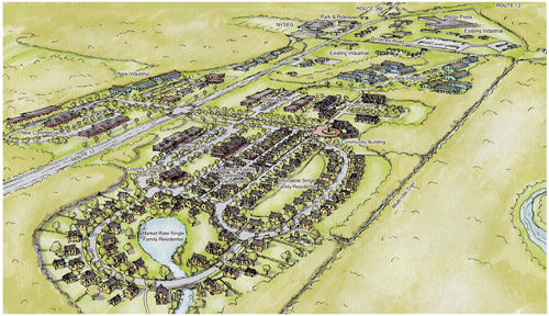
The Route 13/366 Corridor Study, for all its flaws, attempts to sell a vision of Dryden. One key piece that it tries to sell is a new "nodal development" east of the NYSEG building, along the 13/366 intersection. The description is pretty broad:
This area has significant potential for creative and forward thinking nodal development patterns as there is a significant amount of open land.
The concept in this area is to transition from the rural character of Route 13, east of the NYSEG area, into mixed use commercial and residential development, then to the existing industrial center. Figure 19 presents a concept layout of the area with single and multi-family homes adjacent to the future Dryden Trail, transitioning into commercial development along Route 13. The south side of Route 13 is limited by the existing topography and the concept presented contains commercial and industrial development along this area.

Proposed development on Route 13/366. (Click for PDF)
It is recommended that the Town coordinate with NYSEG on the relocation of the existing power lines and substation, north of Route 13. These facilities could detract from the final layout, look, and feel of the area. Further, as recommended above, the access to the development should be centralized and traffic calmed. A roundabout would be one possible way to slow traffic through the area and improve the safety. A second roundabout could be located at the western Route 13/366 intersection to again calm traffic and improve safety for the traveling public. (32)
Since it's hard to imagine what would motivate the creation of this complex, why is this interesting?
Well, for one thing, the document is effectively making a sales pitch. The creators of this plan hoped to make a difference in local zoning, and thought the way to do so was to present an attractive vision of what their planning vision might help create. And what did they come up with?
There's a lot of new light industrial here, mostly placed on the north side of 13 and closer to Pinckney Road. There's new commercial on both sides of 13, and there's a lot of residential. They seem to have understood that business comes from the road, as the commercial is definitely designed to take advantage of the traffic passing by - and there's some kind of large traffic-calming device at the main intersection.
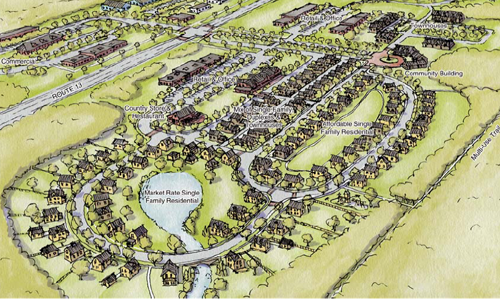
What about that residential, though? How large is it? It's a little tricky reading this from a concept diagram, but there's actually enough detail for it to be useful. Comparing it with tax parcel maps suggests that it takes up around a quarter or more of two largely empty parcels, 44.-1-8 and 44.-1-9. They total 144 acres, but let's call this 30 acres for now.

Zooming in to residential. (Click for PDF)
I counted buildings this morning, and found 30 market rate single family residential, 7 buildings in that area which are garages, accessory apartments, or both, 35 affordable single family houses, 15-20 townhouses, and around 30 likely units in the single/duplex/townhouse mix. That's about 122 units of housing in something like 30 acres - around 4 units per acre, surrounded by forest and along a trail. Even if I've miscalculated and it's 6 per acre, it's still definitely a lot less than 10 or 16.
I'd suggest that this is the kind of vision that results when selling your (weakly-justified) vision forces you to ask "what might people around here like?" instead of "how many units can I cram on that hillside?". It's not just a mix of uses, but a mix of housing types. There are corners of higher density, true - but the overall density stays within bounds that I haven't heard many residents argue is too high.
Posted by simon at December 7, 2010 11:56 AM in Route 13/366 , Varna II , nodal development , planning and zoningNote on photos